APPENDIX 3: How to Do Research at the Land Registry Office
This guide will help you understand the basic rules for doing research at the Land Registry Office on Etobicoke.
LEGAL ADDRESS
To research a specific property, you first need to obtain its actual “legal address”. If you are researching your own property, all you need to do is look at your property tax bill and write down the information that appears near the top of page 1 beside “Legal Description."
If you are researching property that is not yours, you can find the legal address information by using the website of the Land Registry Office and doing a Property Search by address: www.onland.ca/ui/80/property/address.
A legal address will look something like the following examples: Conc I, Lot 16, ND FTL; Conc 2, Lot 15 FTH; Conc 1, Lot 9 BF FTL; RP 66R17310 Part 2 Lot 68; Plan 28, Lot 4. Copy down the information very carefully, including all spaces. (Conc = Concession; ND = North Division; FTL = Fronting The Lake; FTH = Fronting the Humber; BF = Broken Front; RP = Registered Plan.)
Also record other details in case you need them in future, e.g. owners’ names, tenant names, owner contact information, lot dimensions/area, year built (often incorrect with very old properties, but might give you a clue), etc.
If the Legal Description does not include both a lot and a concession number, it will help your search considerably if you can find the original (18th-19th century) surveyed lot and concession numbers. The best source for this information is the map of Etobicoke found in the 1878 York County Atlas on-line by CLICKING HERE.
When you get there, click on “MAPS” and then “York County 22” (at the right side.) Then click on “Etobicoke” in the bottom left corner of the map, and then click “To view a larger version of this map click here.” Click on the area of the map of Etobicoke that interests you to see a closer view.
LAND REGISTRY OFFICE
Once you have the legal address, including original lot and concession number, go to the Land Registry Office website (ONLAND) and search the Historical Books where you can find the complete ownership history of the property, right back to the original land grant. Land Registry records before the year 2000 are free to access and download: help.onland.ca/en/historical-books/.
For information on how to use the Historical Books, please see the ONLAND Help Centre: help.onland.ca/en/category/faqs/historical-books/.
Many properties have multiple changes in legal address under various different Plan numbers over the years. If you’re interested in the entire history of a property from original land grant to now, start with the oldest records using the lot and concession number and move forward in time. If you’re only interested in more modern history, start with the current legal address and go backwards in time. You need to follow what the records tell you, and as areas developed, part of a lot may end up within a different Plan number, so you’ll then need to find the new Plan. Ultimately you may end up searching through several different Plans and file numbers to find the entire history of any one property.
Plans often provide useful information that is not in the other registry records and give you a visual feel for what the property looked like, e.g. it may show buildings, owner names, etc. Plans can downloaded from the ONLAND website for small fee: help.onland.ca/en/documents-search/.
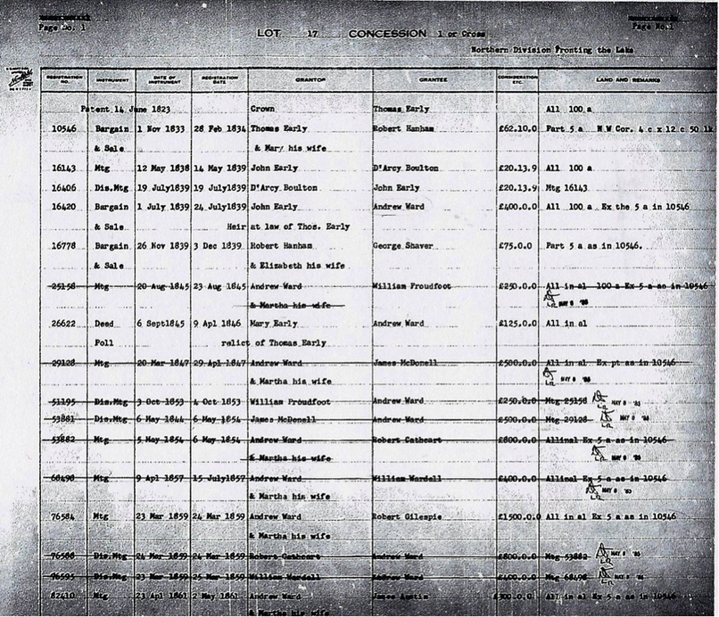
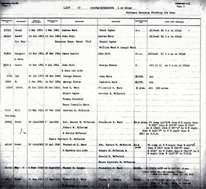
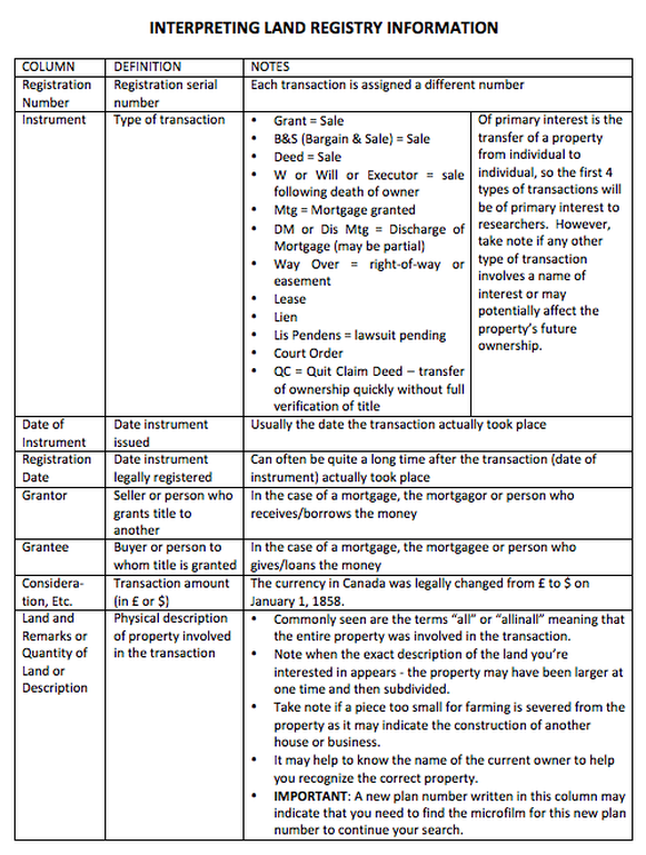
Below are the first two pages of the Land Registry records for Lot 17, Concession 1 (or Cross), Northern Division Fronting the Lake. that was the original legal address for the property now at 3904 Bloor St. W. Right after those two pages is an explanation of each column in the land records.
For guidance on using the above in your research, refer also to the Etobicoke Historical Society's GUIDE: How to Research Etobicoke History.


