
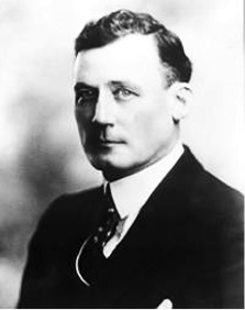
Robert Home Smith
Robert Home Smith is best remembered today for his development of The Kingsway and for his Old Mill Restaurant, which has been a fixture in Toronto since it opened on the day war was declared in 1914. But he was much more than a visionary who shaped a major area of Toronto... he was a dynamic business leader who made a fortune in a variety of business ventures and who played a major role in shaping Toronto's portlands and lakeshore areas, including Sunnyside.
In the language of his times, Robert Home Smith was a “man of affairs”.
The Life of Robert Home Smith
Born in Stratford, Ontario in 1877, he was interested in arts and architecture when he was young. His family insisted that he study law, so he graduated from Osgoode Hall and was called to the bar in 1899. However, in 1901 he suffered an illness (thought to be meningitis) and was left with impaired hearing. This left him despairing of any “dreams of a spectacular courtroom career, debate in the public forum, and high political office”, as biographer James H. Gunn put it.
In 1902, Home Smith joined National Trust Company's estates department, acting as trustee for many businesses forced into bankruptcy. However, it is his involvement with many civic and public organizations that had a major impact on the development of Toronto as we know it today.
Robert Home Smith
Home Smith made a wide variety of personal investments in railways, mills, shipping and real estate, with the bulk of his wealth coming from speculation in northern Ontario mining.
The breadth of his business interests is perhaps best indicated by his position as President of The Mexico Northwestern Railway Company, incorporated in Canada in 1909 under the direction of Fred Stark Pearson. It ran between El Paso, Texas and the lumbering, mining and agriculture areas of the northern Mexican state of Chihuahua. The firm purchased four short railways and constructed one. It also acquired extensive timber lands and lumber businesses, and formed the Madera Company with two lumber mills, as well as the El Paso Milling Company in Texas.
The area served by the railway was very active during the Mexican Revolution, and Home Smith was actively involved in negotiating with both the government and the revolutionaries (including Pancho Villa) to protect the company's interests. Pancho Villa captured Chihuahua and other northern areas, so had a major impact on the railway's operations. A photo of Home Smith with Pancho Villa reflects the close relationships that were necessary to keep the railway in operation.
Home Smith once said that over a hundred of the battles during the Mexican Revolution were fought along the railway line. Similarly, he told a meeting of railway executives in Toronto that he knew more about running a railway than they did, since he kept his running during a very active revolution. He certainly had a valid point.
Home Smith was a dynamic, charismatic civic figure, too. He was a prominent member of the Toronto Guild of Civic Art. This group was made up of architects, local politicians, businessmen and artists who actively promoted the “City Beautiful” movement. The Guild released a comprehensive plan for the development of the city in the first decade of the 20th century, promoting a park system, landscaped parkways, thoroughfares cutting across the city at diagonals, and public squares surrounded by grandiose buildings.
In a speech to the Canadian Club in November 1913, Home Smith asked, “Are you going to have a Birmingham or a Pittsburgh or a London or Paris?” The Guild saw large scale, deliberate city planning as a means of balancing public and private interests. For Home Smith, his private developments met the aims of the Guild.
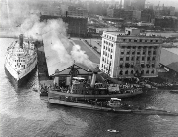
He was also an active and prominent member of the Board of Trade. In 1910 the Board of Trade actively campaigned for a new organization to take over responsibility for the waterfront from the Harbour Trust, which had allowed railways to crowd out other uses along the lakeshore. The harbour was silting up, and raw sewage was being dumped into the harbour, posing both shipping and health problems.
A referendum was held on January 2, 1911 that approved a new Toronto Harbour Commission to take over the harbour and waterfront. The new organization was responsible for redeveloping the waterfront from Victoria Park to the Humber River. Home Smith served on the commission until 1923, acting as president from 1921.
The breadth of his business interests is perhaps best indicated by his position as President of The Mexico Northwestern Railway Company, incorporated in Canada in 1909 under the direction of Fred Stark Pearson. It ran between El Paso, Texas and the lumbering, mining and agriculture areas of the northern Mexican state of Chihuahua. The firm purchased four short railways and constructed one. It also acquired extensive timber lands and lumber businesses, and formed the Madera Company with two lumber mills, as well as the El Paso Milling Company in Texas.
The area served by the railway was very active during the Mexican Revolution, and Home Smith was actively involved in negotiating with both the government and the revolutionaries (including Pancho Villa) to protect the company's interests. Pancho Villa captured Chihuahua and other northern areas, so had a major impact on the railway's operations. A photo of Home Smith with Pancho Villa reflects the close relationships that were necessary to keep the railway in operation.
Home Smith once said that over a hundred of the battles during the Mexican Revolution were fought along the railway line. Similarly, he told a meeting of railway executives in Toronto that he knew more about running a railway than they did, since he kept his running during a very active revolution. He certainly had a valid point.
Home Smith was a dynamic, charismatic civic figure, too. He was a prominent member of the Toronto Guild of Civic Art. This group was made up of architects, local politicians, businessmen and artists who actively promoted the “City Beautiful” movement. The Guild released a comprehensive plan for the development of the city in the first decade of the 20th century, promoting a park system, landscaped parkways, thoroughfares cutting across the city at diagonals, and public squares surrounded by grandiose buildings.
In a speech to the Canadian Club in November 1913, Home Smith asked, “Are you going to have a Birmingham or a Pittsburgh or a London or Paris?” The Guild saw large scale, deliberate city planning as a means of balancing public and private interests. For Home Smith, his private developments met the aims of the Guild.
He was also an active and prominent member of the Board of Trade. In 1910 the Board of Trade actively campaigned for a new organization to take over responsibility for the waterfront from the Harbour Trust, which had allowed railways to crowd out other uses along the lakeshore. The harbour was silting up, and raw sewage was being dumped into the harbour, posing both shipping and health problems.
A referendum was held on January 2, 1911 that approved a new Toronto Harbour Commission to take over the harbour and waterfront. The new organization was responsible for redeveloping the waterfront from Victoria Park to the Humber River. Home Smith served on the commission until 1923, acting as president from 1921.
The Toronto Harbour Commission building, originally right on the lake. Because of infill, today it is on Harbour St. west of Bay.
Commission plans included the creation of Sunnyside Beach and a breakwater from the Humber River to Bathurst Street, as well as filling in much of the shoreline. In the east, the Don River marshlands were filled in, creating industrial and port lands. All of these projects were completed while Home Smith was on the board.
This redevelopment plan resulted in the creation of Lakeshore Drive and the building of Sunnyside Amusement Park on reclaimed land. Costing $13 million, the redevelopment plan was funded by the federal government.
In officially opening the Sunnyside Amusement Park on June 28, 1922, Home Smith as chairman of the Toronto Harbour Commission proclaimed a new era for the city, saying, “Toronto is upon the eve of the greatest development in its history. I am quite sure if we try to rise to it we will be in reality – what is only now in promise – a truly great city.”
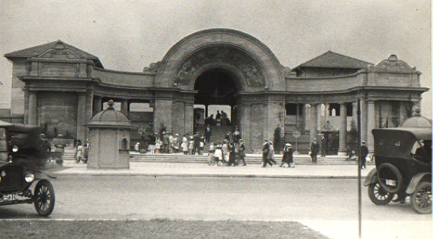
In 1922 the Sunnyside Bathing Pavilion was opened to help bathers change for a swim in the lake. The $300,000 structure provided over 700 lockers for swimmers and a roof garden for 400. Admission fees were 25 cents for adults, 15 cents for children.
This redevelopment plan resulted in the creation of Lakeshore Drive and the building of Sunnyside Amusement Park on reclaimed land. Costing $13 million, the redevelopment plan was funded by the federal government.
In officially opening the Sunnyside Amusement Park on June 28, 1922, Home Smith as chairman of the Toronto Harbour Commission proclaimed a new era for the city, saying, “Toronto is upon the eve of the greatest development in its history. I am quite sure if we try to rise to it we will be in reality – what is only now in promise – a truly great city.”
In 1922 the Sunnyside Bathing Pavilion was opened to help bathers change for a swim in the lake. The $300,000 structure provided over 700 lockers for swimmers and a roof garden for 400. Admission fees were 25 cents for adults, 15 cents for children.
Sunnyside Bathing Pavilion.
In 1925, because the lake had been too cool for swimming the previous two summers, the heated Sunnyside Pool (nicknamed “The Tank”) opened adjacent to the Bathing Pavilion. Able to accommodate 2000 swimmers, it was the largest outdoor pool in the world. Admission was 35 cents for adults, 10 cents for children.
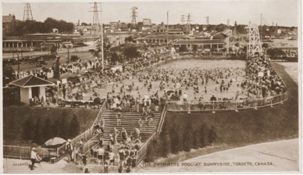
Sunnyside Pool.
The Sunnyside Amusement Park opened in 1922 by Home Smith is best remembered for its many rides. The Flyer roller coaster was the biggest attraction. It hit top speeds of 65 miles per hour, generating much excitement in those slower-paced days.
Sunnyside Amusement Park was torn down in 1955 to make room for the Gardiner Expressway. After it closed, its original 1922 handcrafted Dentzel carousel was moved to Disneyland in California, where it still operates with some changes. Now named King Arthur’s Carousel, its giraffes, deer and other animals were replaced with white horses because “Walt wanted everyone to ride a galloping horse like King Arthur”. Many of the removed animals were relocated to the Casey Jr. Circus Train ride at Disneyland.
Sunnyside Amusement Park was torn down in 1955 to make room for the Gardiner Expressway. After it closed, its original 1922 handcrafted Dentzel carousel was moved to Disneyland in California, where it still operates with some changes. Now named King Arthur’s Carousel, its giraffes, deer and other animals were replaced with white horses because “Walt wanted everyone to ride a galloping horse like King Arthur”. Many of the removed animals were relocated to the Casey Jr. Circus Train ride at Disneyland.
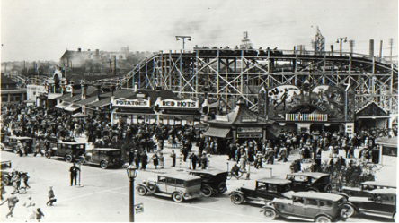
The Flyer Seen behind Several Concession Stands.
Sunnyside’s Derby Racer carousel was also saved and moved to the CNE where it continued to operate until the early 1980s.
It is fitting that we recognize the enormous contribution Robert Home Smith made to this part of Toronto's history through his role with the Toronto Harbour Commission.
His Grand Vision
We will never know precisely what sparked Robert Home Smith's grand vision for the Humber River developments that led to the Old Mill Restaurant, Riverside Drive, Baby Point, St. George’s Golf Course and The Kingsway. However, there are some clues in his days managing National Trust's estates department.
One of Smith’s more spectacular achievements was his handling the bankruptcy of York County Loan and Savings Company. Speculation is that the bankruptcy was politically inspired, but the firm ran into financial difficulty while it was developing the High Park Boulevard and High Park Gardens areas. Its debts were $900,000 when Home Smith took over as trustee in 1905, but he recovered $1,500,000 from its assets. This undoubtedly convinced him that high end housing developments could be profitable. Actually, both his father and grandfather Lizars were property owners and developers in Stratford, so it could be said that it ran in the family.
There may have been another factor drawing his attention to the Humber Valley. His mother's sister, historian Kathleen Macfarlane Lizars, was writing a book The Valley of the Humber 1615-1913, which exhaustively covered the history of the area. (The book has the Home Smith logo on the last page!)
In any case, Home Smith began acquiring vast tracts of land in the Humber Valley and adjacent areas, using his own resources and financing from both Canadian and British investors including the Canadian-born British newspaper magnate Max Aitken, Lord Beaverbrook. Ultimately, he acquired 3000 acres in Etobicoke, as well as substantial property elsewhere.
This financing is reflected on the first page of his 24-page 1912 brochure promoting the Humber Valley Surveys, where it lists as proprietors The Toronto Land Corporation Ltd. and The Valley Land Co. Ltd. On the following page Home Smith & Co. is listed as the “Managers of the Humber Valley Surveys.” All three companies show the same 18 King Street West address.
The extent of the financing is perhaps best reflected in Home Smith’s statement to the Islington Businessmen's Association on May 10, 1928 when he said, “I propose in the next ten years and have arranged for it, to spend on this property a million dollars a year... We are going to put up something so much better that people will come to see what we are doing. We will show what planning can do.”
“Angliae para Anglia procul”, or “A bit of England far from England”, is the opening sentence in the promotion piece for his big project – describing his guiding motivation in the development of the Humber River. His aim was to have a noble city park and boulevard, with the whole development of street planning, architecture and construction producing “A bit of England far from England.”
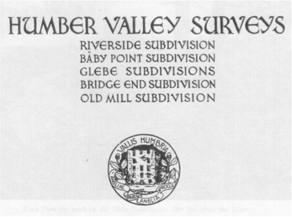
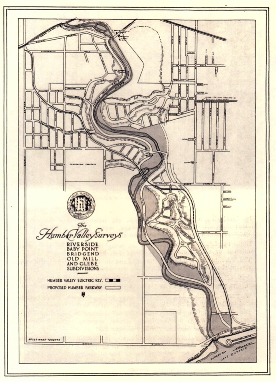
This 1912 brochure introducing the Humber Valley Surveys listed plans for five major subdivisions. The Glebe subdivision is part of today's Kingsway.
The brochure noted above is replete with photos of the Humber taken from the banks above the river, as well as photos showing
dozens of boaters with the caption, “A Saturday afternoon on the Humber.”
The brochure outlines the necessary services that will be available, but cautions that “some years must elapse before the complete city sewer system can be constructed... Meanwhile, cesspools can be installed at a small cost and with satisfactory results.”
Reflecting Home Smith's experience with and interest in railways (he served as president of a railway running between El Paso, Texas and Chihuahua, Mexico from 1916 to 1929, and was also involved with several other railways, including the Algoma Central), some of the more grandiose proposals in the brochure include rail service. “The Toronto Suburban Railway, then under construction, would serve the Glebe and Old Mill subdivisions. That line would run from the intersection of Church Street [Royal York Road] and Dundas Street on the west side of the river, to the intersection of Yonge Street and the Canadian Pacific Railway, the trip taking seventeen minutes.
“The Humber Valley Electric Railway will run from Sunnyside to Lambton. The route leads by the east bank of the River to Bloor Street, where the river will be crossed, and thence to the intersection of Church Street and Dundas Street, the trip taking, from the Riverside Subdivision to Sunnyside, eight minutes, and from the farthest point of the Glebe subdivision, fifteen minutes.”
These railway lines were never put into service, though a similar line had run from Sunnyside to Dundas Street on the east side of the Humber (along Humbercrest Boulevard) for about two years in the 1890s as part of the Belt Line Railway.
The brochure refers to “a noble city park and boulevard” with a Humber Valley Drive running up the west side of the Humber between today's Old Mill and Dundas Street. This is today's Home Smith Park Road, still a delightful drive today, one-way southbound, beside the Humber River.
To achieve this, Home Smith donated 105 acres of valley land on the west side of the Humber to the city, but with some controversial conditions. He made the donation contingent on the city completing the scheme by expropriating two pieces of property: one on the east bank of the river near its mouth and the other land in the valley near the Old Mill which he had been unable to acquire.
The Watson property near the river mouth was acquired by the city and remains largely in its natural state today. The second property, Purity Springs, is near the current bridge crossing over the Humber at the Old Mill. It flooded in the spring when the ice on the river broke up and deposited ice floes ten to fifteen feet high on shore. This still happens occasionally, with the ice covering the Old Mill tennis courts and the parking lot for Etienne Brulé Park.
The most controversial part of the transfer was a court case in which Home Smith claimed that the main course of the Humber had shifted eastward after a major storm and he now owned virtually all of the flats. Despite expert testimony disputing this claim, the court ruled for him and the transfer of the park lands went ahead.
The brochure proclaims, “A permanent roadway of two and one-half miles is now in course of construction from the Lake Shore Road to Bloor Street, on the east side of the River, extending thence to the farthest point of the Glebe subdivision. The Kingsway is one hundred feet wide; the other streets are in proper proportion, the minimum being sixty-six feet. Generous allowance is made at street intersections for shrubberies, etc. And an appropriation will be made for tree and shrub planting, stone gateways, and kindred ornamentation.”
Then came the railway proposal which explains why the Kingsway's homes are set so far back from the road. “The Humber Valley Electric Railway, upon which construction will begin early in the spring of 1913, will run up the ravine on the east side of the [Riverside] subdivision and will be within a few hundred yards of all the lots.
“The Kingsway, a street one hundred feet wide, leads diagonally across the [Glebe] subdivision... and the Humber Valley Electric Railway will run in the center of the Kingsway.”
Since the railway line was never built in the centre of The Kingsway, the extra width of the street means that the houses are set further back from the curb, giving them bigger front lawns. Home Smith had hoped to extend the railway to Caledon, where he also had extensive land holdings, but this dream never came true.
The Garden of Eden
How do you introduce a completely new approach to selling real estate? For Robert Home Smith, it was no real problem. He came up with a vision of his own “Garden of Eden”, then set about to create it. He wanted to build a master community based on the best in England in his own 3000 acre development on the Humber Valley. It's how he achieved this that made all the difference.
He pioneered an innovative approach – putting restrictions on the type and size of buildings which could be constructed in his developments and retaining final approval of all designs. Buyers had to sign 30-year covenants attached to their deeds of sale. Design requirements did not allow much leeway, and the original one page list of requirements soon grew to nearly two pages as Home Smith refined his approach to achieve his goal of “a bit of England, far from England.”
Home Smith & Company offered both architectural and construction services, but buyers could opt for independent architects and contractors. However, Home Smith still retained final approval of any design and materials used.
The focal point of his marketing effort was the area adjacent to the “Old Mill” on the Humber River. Built by William Gamble in 1849, this mill burned in 1881, but remained a picturesque ruin by the Humber until 2001.
Home Smith and Company opened the Old Mill Tea Garden next to the Old Mill ruins on August 4, 1914 – the day that war was declared. While modest in size, this Tea Garden grew into today's landmark Old Mill Inn and Spa, with today's inn incorporating the stones from the ruins of the Old Mill.
In the “Humber Valley Surveys,” Home Smith describes his plans for future facilities:
“The Old Mill, where navigation ends, will be recon-structed as a restaurant and equipped for club purposes. Travellers wrote in the eighteenth century of the beauties of this spot. In the fore-bay, now shaded by willows, bowling greens will be laid out; to the south, tennis courts will have ample space; the Humber Valley Boulevard will pass by the doors; and by land or water a delightful resort will be easily reached. A wharf will accommodate motor boats and all the varieties of pleasure craft that find their way up from the lake front.”
The Old Mill Tea Garden was built in Home Smith's favoured Tudor style, but it also featured an outstanding set of recreational facilities. By 1915, as Home Smith had promised, it offered a boathouse and canoe livery on the Humber River, tennis courts and a lawn bowling green, as well as a three-hole golf course.
Expansion and innovation in the Old Mill Tea Garden continued over the years. By 1918 dancing to recorded music was offered, and in 1921 the first “live” music was offered by violinist Cec Ryder with Nelson Hatch on the piano in what is now the Print Room. When a new dance floor was added in 1929, Nelson Hatch opened with a nine-piece orchestra.
In 1928, the former William Gamble house on a hill above the Old Mill ruin was demolished and Home Smith & Company opened a new Administration Building, moving its head office to this location. The building not only housed Home Smith & Company's accounting, architectural and administration departments, but also offered a post office and a branch of the Bank of Nova Scotia (1930 to 1938).
The new structure later housed the offices of architects Robert S. Hanks and Norman L. Irwin, who worked in the architectural department of Home Smith & Company until they formed their own partnership in 1939. The office building was connected to the greatly expanded Old Mill Restaurant by an underground passage and a stairway to ground level.
In 1916, the iron bridge over the Humber River was swept away by ice, and in 1917 the City replaced it with the current stone arch bridge. Straightening of Bloor Street and construction of the present high level bridge over the Humber River was completed in 1924.
But the Old Mill Tea Garden wasn't the only part of the sizzle that Home Smith used to sell his project's steak. He also opened a restaurant and a second-floor dance hall in the Lambton Mills Inn, located in William Howland's former mill on Dundas Street, east of the Humber River. Easy access to this site was provided by the Toronto Suburban Railway running along Dundas Street. However, this building burned down, leaving the Lambton Tavern as the only original commercial building still standing in the village of Lambton Mills today.
Opening the Gates with Baby Point
Easy access was the key to selling the first subdivisions in the Humber Valley Surveys, so Home Smith started promoting the subdivisions on the east banks of the Humber. “The Baby Point Subdivision is situated on the east bank of the Humber River, about half-way between Bloor Street and Dundas Street.” says a 1912 brochure.
“The main roads are now graded and gravelled, and are in good condition. Work on the section of the Humber Boulevard which runs past the front of this property will be begun early in 1913.”
“The Ontario Railway Commission have ordered a car line to be built at once on Annette Street as far as Jane Street, to the entrance of the property.”
Today the site has dozens of multi-million dollar homes (particularly on the ravine lots west of Humbercrest Blvd.) and is one of the prime real estate areas in Toronto.
Raymond and Francis (Frank) Baby lived in this house at the southern foot of Baby Point until they sold it in 1880. Frank then built a brick house on Jane Street just north of Annette.
Interesting, but it only told a part of the fascinating story of Baby Point.
Paintings show how Taiaiagon looked on the Baby Point site. The Seneca lived in the village and grew crops on the river banks below. Baby Point was the site of Taiaiagon, the only Iroquois village on the north shore of Lake Ontario. Natives from the Seneca tribe in what is now New York lived here in 1615 when Etienne Brulé arrived, despite being enemies of the Hurons who dominated the north around Lake Huron.
Today, a 1949 plaque mounted on a stone at the east end of the Baby Point Club property carries the inscription:
“This area includes the site of Taiaiagon Iroquois village at the foot of the Toronto Carrying Place...This way passed the first white man to see Lake Ontario 1615: René Robert Cavalier de la Salle, explorer of the Mississippi 1680 and 1681; John Graves Simcoe, first Lieutenant-Governor of Upper Canada, 1793. These lands now known as Baby Point were purchased by Honourable James Baby, member of the Legislative and Executive Councils, 1820.”
The Humber River was the 30-mile portage (now called the Toronto Carrying Place) between here and the Holland River (about Highway 9 today), leading into Lake Huron. In 1687 the French Governor-General Denonville, burned Taiaiagon to punish the natives for trading with the English and Dutch (as the rest of the tribe to the south did). The river shore area below Baby Point was resettled by the Mississauga tribe (Ojibway) for about fifty years, until fishing and hunting was decimated by European settlement and clearing.
Significant artifacts found on Baby Point include a leather withe with eight iron axe heads attached to it. Now in the ROM, it was used to torture prisoners when the axe heads were heated and hung around the prisoner's neck.
The first European-built structure in the Toronto area was built on the southern edge of Baby Point in 1720 when the French built a small fort and trading post (known as Magasin Royal or the Royal Store of Toronto) and staffed it with two soldiers and a manager. A second and larger Royal Store was later built further south near the mouth of the Humber.
Baby Point also had a direct connection to Lieutenant Governor Simcoe. When he was captured during the American Revolutionary War as a colonel of the Queen's Rangers, he was imprisoned with a British-supporting lawyer named John Browne Lawrence. One of the last acts Simcoe performed as Lieutenant Governor, just before he returned to England, was approving an application from Lawrence for a land grant on the east side of the Humber, extending from the Old Mill up to Dundas Street.
Lawrence became the owner of the property on Sept. 1, 1797 and promptly built a mill powered by the eastern branch of the Humber on the island that separated the Humber into eastern and western branches near where the Old Mill was located on the western branch. Lawrence died in 1798, and the land was auctioned in 1820 when James Bâby (the first Canadian-born member of Simcoe's executive Council) purchased a section of this land covering today's Baby Point and the Old Millside area to the south, which was used as his family farm.
Two of his sons, Raymond and Francis (Frank) Bâby lived on the farm with the lower section of the property growing fruit trees, while he lived in more comfortable rented accommodations in York. Raymond Avenue in the subdivision was named after Raymond, whose main claim to fame is that he was part of the mob that raided firebrand William Lyon Mackenzie's print shop and tossed his type into the harbour because of his writing against the governing Family Compact, of which Bâby was a principal player.
The gates above were built in 1912 at the entrance to the subdivision. The original brochure promoting the subdivision featured a drawing showing Home Smith's idea of the homes that would be built in Baby Point with the caption “Houses to be constructed during 1913 on Baby Point Road.”
Baby Point Club property was bought for $5,000 by local residents and set up as a private, non-profit community club in 1923. Offering tennis and lawn bowling, as well as a host of social and sporting activities, the club plays a major role in the community's life. The clubhouse was started in 1930 and has seen multiple expansions.
The construction schedule was somewhat optimistic. By 1923 there were 13 houses in the Baby Point subdivision. A letter from Ann Bell, one of the earliest residents, says that in 1919 Home Smith was considering selling the one acre site at the junction of Baby Point Road and Baby Point Crescent. She, and other residents, convinced him not to sell and reserve the site for a community club.
In 1923, the owners, together with other interested persons, established an organization called the Baby Point Club Ltd. and bought the one-acre site that Home Smith had reserved for a community park for $5000.
Baby Point Club Limited was issued its letters patent on November 30th, 1923. Directors listed on the original letters patent were:
Mr. Hamilton became the first president of the Club and played an important role in financing the Club. He provided a $2,500 mortgage payable $100 half-yearly. His heirs extended the mortgage for five years in 1942, with payments of $50 half-yearly. Hamilton also donated the fence around the Club and the gates to the Club in memory of his late wife.
Another long-time member was involved with the fences and gates. They were provided by the Lundy Fence Company Ltd. in November, 1930. A.H. Lundy lived at 15 Baby Point Cres, but subsequently moved across the Point to 70 Baby Point Road.
The current club house was started in 1930, a fraction of its current size. Access to the basement was through a trap door and ladder leading down. Later extensions added a kitchen and washroom, while expanding the main floor meeting room as well as entrance way and patio.
Today the club is one of two community clubs in Toronto which own their own property and pay property taxes rather than rent for city property. This approach to developing the community paid off in a community fitting Home Smith's vision.
Easy access was the key to selling the first subdivisions in the Humber Valley Surveys, so Home Smith started promoting the subdivisions on the east banks of the Humber. “The Baby Point Subdivision is situated on the east bank of the Humber River, about half-way between Bloor Street and Dundas Street.” says a 1912 brochure.
“The main roads are now graded and gravelled, and are in good condition. Work on the section of the Humber Boulevard which runs past the front of this property will be begun early in 1913.”
“The Ontario Railway Commission have ordered a car line to be built at once on Annette Street as far as Jane Street, to the entrance of the property.”
Today the site has dozens of multi-million dollar homes (particularly on the ravine lots west of Humbercrest Blvd.) and is one of the prime real estate areas in Toronto.
Raymond and Francis (Frank) Baby lived in this house at the southern foot of Baby Point until they sold it in 1880. Frank then built a brick house on Jane Street just north of Annette.
Interesting, but it only told a part of the fascinating story of Baby Point.
Paintings show how Taiaiagon looked on the Baby Point site. The Seneca lived in the village and grew crops on the river banks below. Baby Point was the site of Taiaiagon, the only Iroquois village on the north shore of Lake Ontario. Natives from the Seneca tribe in what is now New York lived here in 1615 when Etienne Brulé arrived, despite being enemies of the Hurons who dominated the north around Lake Huron.
Today, a 1949 plaque mounted on a stone at the east end of the Baby Point Club property carries the inscription:
“This area includes the site of Taiaiagon Iroquois village at the foot of the Toronto Carrying Place...This way passed the first white man to see Lake Ontario 1615: René Robert Cavalier de la Salle, explorer of the Mississippi 1680 and 1681; John Graves Simcoe, first Lieutenant-Governor of Upper Canada, 1793. These lands now known as Baby Point were purchased by Honourable James Baby, member of the Legislative and Executive Councils, 1820.”
The Humber River was the 30-mile portage (now called the Toronto Carrying Place) between here and the Holland River (about Highway 9 today), leading into Lake Huron. In 1687 the French Governor-General Denonville, burned Taiaiagon to punish the natives for trading with the English and Dutch (as the rest of the tribe to the south did). The river shore area below Baby Point was resettled by the Mississauga tribe (Ojibway) for about fifty years, until fishing and hunting was decimated by European settlement and clearing.
Significant artifacts found on Baby Point include a leather withe with eight iron axe heads attached to it. Now in the ROM, it was used to torture prisoners when the axe heads were heated and hung around the prisoner's neck.
The first European-built structure in the Toronto area was built on the southern edge of Baby Point in 1720 when the French built a small fort and trading post (known as Magasin Royal or the Royal Store of Toronto) and staffed it with two soldiers and a manager. A second and larger Royal Store was later built further south near the mouth of the Humber.
Baby Point also had a direct connection to Lieutenant Governor Simcoe. When he was captured during the American Revolutionary War as a colonel of the Queen's Rangers, he was imprisoned with a British-supporting lawyer named John Browne Lawrence. One of the last acts Simcoe performed as Lieutenant Governor, just before he returned to England, was approving an application from Lawrence for a land grant on the east side of the Humber, extending from the Old Mill up to Dundas Street.
Lawrence became the owner of the property on Sept. 1, 1797 and promptly built a mill powered by the eastern branch of the Humber on the island that separated the Humber into eastern and western branches near where the Old Mill was located on the western branch. Lawrence died in 1798, and the land was auctioned in 1820 when James Bâby (the first Canadian-born member of Simcoe's executive Council) purchased a section of this land covering today's Baby Point and the Old Millside area to the south, which was used as his family farm.
Two of his sons, Raymond and Francis (Frank) Bâby lived on the farm with the lower section of the property growing fruit trees, while he lived in more comfortable rented accommodations in York. Raymond Avenue in the subdivision was named after Raymond, whose main claim to fame is that he was part of the mob that raided firebrand William Lyon Mackenzie's print shop and tossed his type into the harbour because of his writing against the governing Family Compact, of which Bâby was a principal player.
The gates above were built in 1912 at the entrance to the subdivision. The original brochure promoting the subdivision featured a drawing showing Home Smith's idea of the homes that would be built in Baby Point with the caption “Houses to be constructed during 1913 on Baby Point Road.”
Baby Point Club property was bought for $5,000 by local residents and set up as a private, non-profit community club in 1923. Offering tennis and lawn bowling, as well as a host of social and sporting activities, the club plays a major role in the community's life. The clubhouse was started in 1930 and has seen multiple expansions.
The construction schedule was somewhat optimistic. By 1923 there were 13 houses in the Baby Point subdivision. A letter from Ann Bell, one of the earliest residents, says that in 1919 Home Smith was considering selling the one acre site at the junction of Baby Point Road and Baby Point Crescent. She, and other residents, convinced him not to sell and reserve the site for a community club.
In 1923, the owners, together with other interested persons, established an organization called the Baby Point Club Ltd. and bought the one-acre site that Home Smith had reserved for a community park for $5000.
Baby Point Club Limited was issued its letters patent on November 30th, 1923. Directors listed on the original letters patent were:
- Robert James Dilworth, Chartered Accountant, 47 Baby Point Crescent.
- Urias Charles Hamilton, Manufacturer, 19 Baby Point Crescent.
- Marcel Turner Morgan, Manufacturer, 112 Farnham Avenue.
- Thomas Powell Wright, Contractor, 31 High Park Blvd.
- William Roy Willard, Barrister, 50 High Park Blvd.
- William Henry Bell, Furrier, 74 Baby Point Rd.
- Albert Franklin Mavety, Physician, 1 Baby Point Rd.
Mr. Hamilton became the first president of the Club and played an important role in financing the Club. He provided a $2,500 mortgage payable $100 half-yearly. His heirs extended the mortgage for five years in 1942, with payments of $50 half-yearly. Hamilton also donated the fence around the Club and the gates to the Club in memory of his late wife.
Another long-time member was involved with the fences and gates. They were provided by the Lundy Fence Company Ltd. in November, 1930. A.H. Lundy lived at 15 Baby Point Cres, but subsequently moved across the Point to 70 Baby Point Road.
The current club house was started in 1930, a fraction of its current size. Access to the basement was through a trap door and ladder leading down. Later extensions added a kitchen and washroom, while expanding the main floor meeting room as well as entrance way and patio.
Today the club is one of two community clubs in Toronto which own their own property and pay property taxes rather than rent for city property. This approach to developing the community paid off in a community fitting Home Smith's vision.
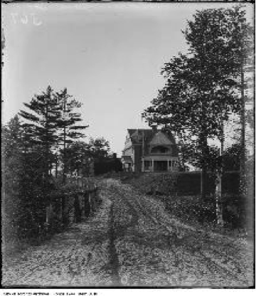
The Riverside Subdivision
Home Smith's plans for the Humber Valley Surveys were based on his belief in the Garden City principles, then popular in England. He decreed “tastefully appointed” traditional English style homes were to be sited on well-treed lots and winding streets to create an air of a wooded retreat. His plans for the Riverside subdivision on the east side of the Humber River best exemplify this.
The original plans for Riverside show today's South Kingsway running north from Lakeshore Rd. to Bloor St., and Riverside Dr. running along the western crest of the hill, eventually running into Garboyd Av. where it descends to meet the South Kingsway today. This fit perfectly with the Garden City design approach. The prime ravine lots with a view of the Humber Valley would be located on the main road through the subdivision.
In the map seen below, the original plan for Riverside showed Riverside Dr. running along the crest of the Humber ravine. But as development progressed, Riverside Dr. straightened out and at the north end, the western road with the ravine lots became Brulé Gardens.
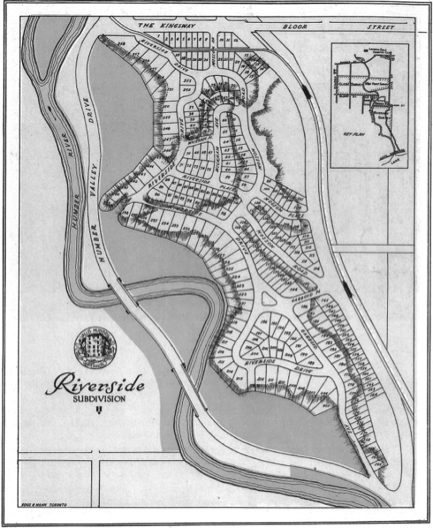
Mossom Rd. was drastically shortened and replaced over much of its length by a realigned Riverside Dr. Riverside Dr. remained the main road through the subdivision, but lost much of its hilltop ravine location. Home Smith's insistence on traditional English-style architecture prevailed and he retained final approval for any building designs, and a 30-year restriction on any changes from approved designs.
There were two major features in the original plans that never developed. They showed an electric railway running from Sunnyside, along the route of today’s South Kingsway, eventually reaching Caledon. Also shown is a Humber Valley Drive running to the west through the river valley and crossing the Humber, eventually running into today's Robert Home Smith Dr. along the west bank of the Humber. This was never built, though the northern extension on the west side of the Humber running south from Dundas St. to the Old Mill is a delightful drive today.
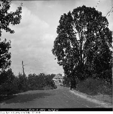
Like the Baby Point subdivision to the north, development proceeded slowly, but generally retained a very high quality of building that enhanced Home Smith’s reputation as a quality developer. The subdivision retained his reputation for exclusivity and became home to many of Toronto's top families.
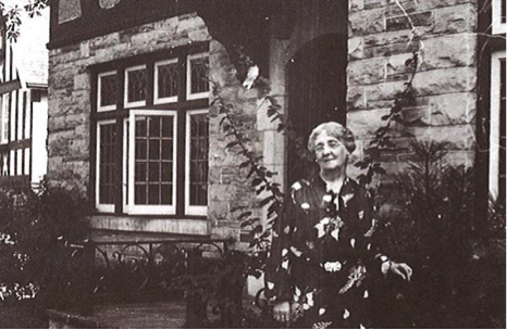
Lucy Maud Montgomery in front of 210 Riverside Drive. The house still stands today.
Undoubtedly the best known resident was Canada's internationally known author, Lucy Maud Montgomery, who wrote 22 best-selling books including Anne of Green Gables. She moved into 210 Riverside Drive in 1935 and lived there until her death in 1942. She wrote the last three of her novels (Anne of Windy Poplars, Jane of Lantern Hill and Anne of Ingleside) while living there.
An extension to the subdivision, the Riverside Extension added lots on the east side of South Kingsway near Bloor Street, accounting for some of the unique homes built in this area.
Innovations for Home Smith in the Riverside subdivision were the construction of a three-unit apartment house with 75-foot frontage. The units sold for $30,000 each. Also, a duplex was constructed on Brulé Gardens in 1935.
Researched and Written by Bruce Glassford
References:
Humber Valley Surveys. Home Smith & Co., 1912.
Files from Keith Spark and Robert A. Given.
Photos from Toronto Public Libraries and torontoplaques.com.
Special thanks to Denise Harris for her valuable suggestions and contributions to this series.